This information is prepared by India Division ATC Operations and is strictly only for Flight Simulation on IVAO.
What is Oceanic Airspace?
Oceanic airspace is airspace located over an ocean that is monitored and controlled by India.
Because substantial volumes of oceanic airspace lie beyond the range of ground-based radars, oceanic airspace controllers have to estimate the position of an airplane from pilot reports and computer models (procedural control), rather than observing the position directly (radar control, also known as positive control).
In addition, oceanic airspace is divided into oceanic information regions and delegated to a controlling authority bordering that region.
Pilots flying over an ocean can determine their own positions accurately using the Global Positioning System (GPS) or inertial flight system and can supply periodic updates to an oceanic controller.
In real aviation, pilots typically use high frequency (HF) radio instead of very high frequency (VHF) radio to communicate with a centre when flying over the ocean, because of HF's relatively greater propagation over long distances. In IVAO, HF is not simulated and the use of one VHF frequency is mandatory as there is no propagation effect in IVAO.
Oceanic Principles
The Oceanic Environment is not serviced by Radar, therefore the only way ATC can provide you with separation, is by every aircraft telling them where they precisely are. To facilitate this, certain reporting procedures are put in place.
The primary difference between flying in this airspace and land-based ARTCC/FIRs is that it is impractical to survey the entire region with radar. Thus air traffic control is accomplished with time-honored non-radar procedures that were honed in the 1940s and 50s before radar coverage was common.
In the real-world environment, the primary communications means are over HF frequencies as opposed to normal land-based VHF frequencies. This band is capable of much greater distance but is highly susceptible to natural interference. Other methods of communications used in the real world are the INMARSAT satellite network and the use of HF “SELCAL” system to alert pilots with a “ping”.
Equipment Requirements
Oceanic Airspace in India require a RNP of 10. A RNP of 10 means that a navigation system must be able to calculate its position to within a circle with a radius of 10 nautical miles. The level of RNP an aircraft is capable of determines the separation required between aircraft.
The reason for this requirement is the lack of radar surveillance, and ATC relies completely on pilot’s position reports. Therefore accurate position reports are a must.
You should become comfortable enough with your equipment to be able to perform the following tasks:
- Build/enter a flight plan into the FMS (or load/convert one of the pre-built flight plan files from our “flight plans” page).
- Detect passing over waypoints.
- Find the estimated time to cross the next waypoint and report it in Zulu time.
- Use your FMS and adjust your speed to be able to cross a waypoint at a given Zulu time.
- Control your aircraft speed by Mach number.
The above tasks are needed to submit proper position reports.
VERY IMPORTANT: Synchronize your watches – Since the Oceanic AREA works by using position reports given with accurate time, all aircraft in the FIR must have their simulator clocks set accurately.
Oceanic Airspaces in India
There are 3 Oceanic regions around Indian airspace:
1) Mumbai Oceanic
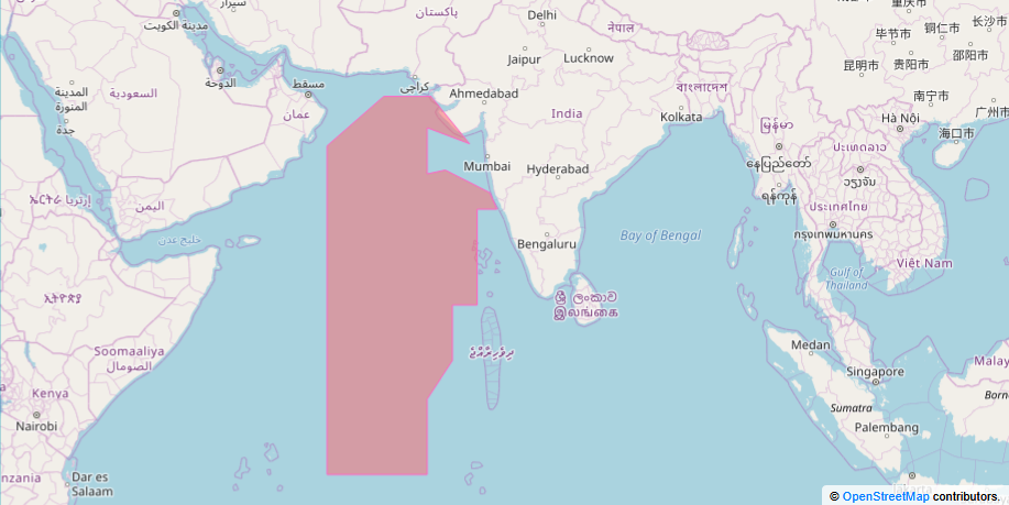
The area bounded by the end of Mumbai area control center to the west until the FIR boundary.
- Callsign: VABF_OC_CTR
- Frequency: 132.600 MHz
- Radio Callsign: Mumbai Radio
2) Chennai Oceanic
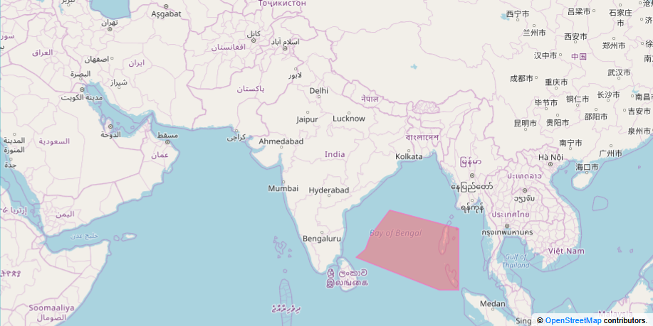
The area bounded by the end of Chennai area control center to the east until the FIR boundary.
- Callsign: VOMF_OC_CTR
- Frequency: 126.150 MHz
- Radio Callsign: Chennai Radio
3) Kolkata Oceanic
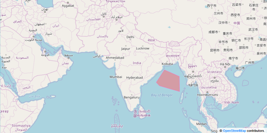
The area bounded by the end of Kolkata area control center to the south until the FIR boundary.
- Callsign: VECF_OC_CTR
- Frequency: 128.300 MHz
- Radio Callsign: Kolkata Radio
Oceanic Clearance
The clearance process for an oceanic flight is similar to a domestic flight with one exception which may arise during exceptionally busy periods (such as a fly-in event involving the oceanic space). The ATC facility handling your departure must obtain an “oceanic clearance” from the Oceanic Centre to ensure the route you are flying has a “slot” for you. This will be based on an estimated time that your flight will reach the first waypoint on the oceanic route. If there is no slot due to forecasted congestion, the Clearance Delivery controller will give you an “oceanic departure time” as the earliest pushback time for your flight.
If you are airborne, coming from another FIR, the Center controller who will hand you off to the Oceanic Controller will obtain an airborne oceanic clearance. If the route is congested, you will probably be vectored or placed into a hold until a slot on your route opens.
Pilots DO NOT have to request an Oceanic Clearance.
Oceanic Entry Handoff
When you approach the border between the land-based FIR, the CTR controller will hand you off to the Oceanic Control (OC). You will be told that radar service is terminated. You are now out of range of land-based radar. Finally, you will be instructed to change to the Oceanic frequency.
NOTE: You are NOT required to squawk 2000 and you may retain your previous squawk Code.
For Example
|
VOMM_CTR:
|
IGO611, Entering the oceanic airspace. Radar service terminated. Report position to Chennai Radio on 126.15
|
|
IGO611:
|
Report position to Chennai Radio on 126.15
|
VERY IMPORTANT: You will be handed off no later than five minutes to the fix on the oceanic route that lies closest to the border between the CTR and the OC. This means you should be ready to submit your first position report to the OC right away. You do need to “check in” with the OC. Just format up your position report and keep it ready as shown in the next section.
Position Reports
Once inside the Oceanic FIR and established on the oceanic route, position reports will be compulsory. That means when you cross each waypoint forming the oceanic route, you are required to submit a position report to the OC.
The report consists of the following elements:
- Last crossed WPT and Zulu time of crossing
- Altitude
- Next WPT and estimated time of crossing
- Name of WPT the next WPT in sequence
- Mach number
- SELCAL code (optional) - Only with the FIRST position Report
Position reports can be submitted Either by Voice/Text or CPDLC.
Example of a Position Report:
| AIC105: |
Chennai Chennai, AIC105, Position Report |
| VOMX_CTR: |
AIC105, Chennai, pass your message. |
| AIC105: |
AIC105 is position IDASO at 17:15 Zulu, FL350. Estimating SADAP at 17:55 Zulu, BASOP next. Mach point 80, SELCAL DQ-CM. |
| VOMX_CTR: |
AIC105, Chennai Radio, position IDASO at 17:15 Zulu, FL350. Estimating SADAP at 17:55 Zulu, BASOP next. Mach point 80, SELCAL DQ-CM. |
| AIC105: |
Readback correct, checking SELCAL |
| *Ping* (SELCAL check is being carried out by the controller) |
| AIC105: |
SELCAL check ok, SELCAL watch 126.15
|
Your next position reports will be identical EXCEPT the SELCAL part which will be omitted.
Position Reports via CPDLC
CPDLC, or Controller-Pilot Datalink Communications is active at all Oceanic Control Areas in India. Position Reports may also be made through it. However, at the correct readback of the FIRST position report by ATC using CPDLC, Pilots must Request a SELCAL check on Voice as it is not possible through CPDLC, neither is the option to add a SELCAL code in it during a position report present.
Pilots shall see the CPDLC in the form of a Flight Management Computer and Controllers will see it in the form of a table after pressing System Access on the following website http://www.virtual-cpdlc.com
There also many options in the CPDLC such as Weather Reports or Mach/FL changes etc. which may be used with Oceanic ATC.
Using CPDLC does not mean it is not required to have established Voice/Text capabilities in case of a CPDLC failure.
ATC Instructions
Remember Oceanic ATC cannot see where you are on a radar-scope, he is relying on you to tell him where you are! This is the principle of Oceanic reporting. To separate traffic on the oceanic routes, ATC has several methods for ensuring separation. The two most likely that will be used, are to separate you vertically by assigning or changing your cruise altitude, or adjusting your airspeed by specifying a mach number.
If issued a speed restriction, you must not alter your airspeed unless obtaining a new clearance from ATC. Similarly, requests to step up or down in altitude may not be cleared immediately. ATC will be operating under the “10 minute rule” or, used in the non-radar environment. Aircraft need 10 minutes between their estimates to cross a given intersection.
You may also be given time restrictions, such as “Cross at or after .” You will need to slow or speed up to your aircraft and observe the impact on your ETA over that .
- Separation for Aircraft on the same track or Airway at the same Cruising Level must be 10 Minutes or 80nm.
- Vertical Separation is 1000ft below FL410 and above that will be 2000ft.
Controllers will be expected to Use CPDLC at ALL times. http://www.virtual-cpdlc.com
Controllers ATIS
Please enter this in the Remarks Section of your ATIS:
http://www.virtual-cpdlc.com in use/Oceanic clearance NOT required/Position reports to include callsign, passed fix & time, estimated fix & estimated time, following fix, FL and mach number. For more information visit http://www.ivao.in/resources/india-oceanic-procedures/
Position Names will be XXXX Radio Eg: Mumbai Radio, Kolkata Radio, Chennai Radio.
SELCAL
SELCAL operates on the high frequency (HF) or very high frequency (VHF) radio frequency bands used for aircraft communications. HF radio often has extremely high levels of background noise and can be difficult or distracting to listen to for long periods of time. As a result, it is common practice for crews to keep the radio volume low unless the radio is immediately needed. A SELCAL notification activates a signal to the crew that they are about to receive a voice transmission, so that the crew has time to raise the volume.
The SELCAL check is carried out after the readback of the first position report.
Once it is successful, you may reduce the volume of the HF receiver. If the OCA needs to talk to you, they will call you with the “SELCAL” message. You should then reply as follows:
AIC105: “Chennai Radio, AIC105, answering SELCAL.”
NOTE: To have this function on IVAO, you need to enter the correct SELCAL code for the registration of aircraft you are flying, entered in your REMARKS section of flight plan Eg. Reg/VTABC SEL/BFKQ
CONTROLLERS PLEASE NOTE
- SELCAL shall be used by right clicking on the aircraft tag in IvAc and pressing SELCAL, or type in . in the commbox. Please note that any aircraft requesting SELCAL must have SEL/XXXX in their remarks section of the flightplan. The SELCAL check shall be carried out on initial call up. Position reports shall be in the same format as that described in the link given in the ATIS and must be read back in the same way. Hand offs to adjacent Oceanic sectors or the Domestic Controllers shall take place at the boundary itself.
- Please note that IVAC should not be used for controlling as it is technically oceanic airspace. Radar Vectoring is prohibited. VFR or SVFR may NOT take place in Oceanic Airspace.
- It is key that the required separation is maintained through the use of position reports. Reports must be given every 45 Minutes or at every Waypoint passed. The Oceanic Airspace does NOT have an upper limit.
Emergency Handling
In the case of an emergency while in Oceanic Airspace, a Mayday or Pan Call must be made to the Respective ATC unit. Pilots may squawk 7700 or 7600 at their own discretion and ATC will not inform them to do so. Pilots will be re routed by the Oceanic Controller in charge and you must provide position time estimates for the waypoints you pass.
Oceanic Exit Handoff
The oceanic routes will have a fix at the border between the Oceanic FIR and your destination FIR. Before crossing this fix the Oceanic Controller shall arrange a handoff to Center. You may be issued a new squawk code before handoff (to facilitate radar identification) or after handoff.
Once handed to Center, you will be radar identified. If you were on an RVSM route, you will be assigned a new altitude complying with standard IFR procedures.